
Tropical Storm Arthur Remnants Trigger Deadly Flooding And Evacuations In Gulf States
Remnants of Tropical Storm Arthur triggered deadly flooding and forced evacuations across Louisiana and Mississippi on Thursday, June 18, 2026, killing two people and flooding hundreds of homes.[1]
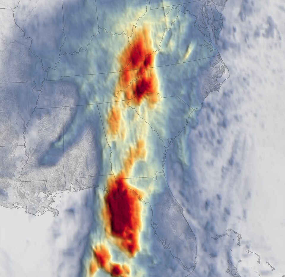
In Avoyelles Parish, Louisiana, more than 2 feet of rain fell in 48 hours, flooding at least 200 homes, officials said.[1] Rescue crews in Perkinston, Mississippi, broke into RVs, used canoe paddles and pulled people from rising water as cars and mobile homes washed away.[1] About 30 homes below the Anchor Lake dam were evacuated as a precaution over concerns the spillway could be overwhelmed.[1] Mississippi Governor Tate Reeves said a county road-crew worker was killed while helping with storm cleanup.[1] A 15-year-old boy apparently drowned in a flooded retention pond outside Houston; his body was recovered using sonar, officials said.[2]
On Wednesday, June 17, 2026, a disorganized cluster of Gulf storms consolidated into Tropical Storm Arthur about 40 miles east-northeast of Port O'Connor, Texas.[3] The National Hurricane Center warned Arthur's main threat was prolonged heavy rain capable of producing dangerous flash and urban flooding from the Texas coast into the Deep South.[2] Forecasters had said Arthur could drop 5 to 10 inches of rain across wide swaths, with isolated totals near 20 inches and a risk of tornadoes.[4]
Early coverage emphasized the system's potential to become the season's first named storm and warned of heavy rain, with forecasters placing formation odds near 70%.[5] Later reporting documented the storm's deadly impacts, widespread evacuations and confirmed tornadoes as the remnants soaked the Gulf states.[1]
The mainstream summary does not mention the broader climatological context in which Tropical Storm Arthur formed. An average of 2.4 named storms typically develop in the Atlantic basin during June, based on data from 1991 to 2020, highlighting that Arthur's emergence is part of a larger seasonal pattern rather than an isolated event. This context may influence public perception of the storm's severity and frequency, which the summary does not address.
Additionally, while the mainstream account focuses on immediate impacts, it overlooks underlying vulnerabilities that exacerbate the effects of such storms. A 2021 study indicates that flood exposure and social vulnerability are particularly pronounced in rural areas of the U.S. South, including Louisiana and Mississippi, driven by factors like poverty and racialized economic disadvantage. This structural explanation suggests that the devastation from Arthur's remnants may reflect deeper systemic issues rather than solely the storm's intensity.[6][7]
Show source details & analysis (10 sources)
📊 Relevant Data
An average of 2.4 named storms form in the Atlantic basin during June based on 1991-2020 climatology.
The 2023 Atlantic Hurricane Season: An Above-Normal Season with a Record Number of Named Storms — Bulletin of the American Meteorological Society
📌 Key Facts
- On Wednesday, June 17, 2026, a disorganized cluster of Gulf storms consolidated into Tropical Storm Arthur — the first named storm of the 2026 Atlantic season — centered about 40 miles east‑northeast of Port O'Connor, Texas, with maximum sustained winds near 40–45 mph and expected to dissipate by Wednesday night or early Thursday, June 18, 2026 (Tropical Storm Arthur).
- The National Hurricane Center warned that Arthur’s primary hazard is a prolonged, multi‑day heavy‑rain event capable of producing dangerous to life‑threatening flash and urban flooding from the Texas coast eastward into the Deep South, and it forecast widespread rainfall of roughly 5–10 inches with isolated totals up to 20 inches and the potential for tornadoes (National Hurricane Center).
- Arthur prompted tropical storm warnings and watches along the Texas‑Louisiana coast (tropical storm warnings from High Island, Texas, to Morgan City, Louisiana, and a watch from Sargent to High Island) and officials cautioned about life‑threatening surf, rip currents and storm surge near and east of the landfall point (tropical storm warnings).
- The system had already drenched parts of Texas and caused flooding in Louisiana as it strengthened; Houston had been under a flood warning since Monday, June 15, 2026, and active flash‑flood warnings were reported in the Houston metro as heavy rain continued (Houston).
- Remnants of Tropical Storm Arthur produced deadly flooding and rescue operations: a 15‑year‑old boy apparently drowned in a flooded retention pond outside Houston (his body was recovered using sonar), and Mississippi authorities reported at least one storm‑related death when a county road‑crew worker was killed while helping with cleanup (Remnants of Tropical Storm Arthur).
- Localized extremes and evacuations included more than 2 feet of rain in 48 hours in Avoyelles Parish, Louisiana, flooding at least 200 homes; life‑threatening floods in Perkinston, Mississippi, that trapped people in a campground and washed away cars and mobile homes; and precautionary evacuations of about 30 homes below the Anchor Lake dam in southern Mississippi (Avoyelles Parish).
- Storm impacts included confirmed tornadoes (one in Avoyelles Parish and three near New Orleans), and local officials — including New Orleans Mayor Helena Moreno — mobilized boats, barricades and sandbag distribution points while the National Guard and state wildlife officials assisted with rescues (New Orleans Mayor Helena Moreno).
📰 Source Timeline (10)
Follow how coverage of this story developed over time
- On Thursday, June 18, 2026, remnants of Tropical Storm Arthur produced torrential rain and strong winds that tore through buildings, flooded homes, and prompted water rescues in Louisiana and Mississippi.
- In Avoyelles Parish, Louisiana, more than 2 feet of rain fell in 48 hours and at least 200 homes were flooded, according to state Rep. Daryl Deshotel and National Weather Service meteorologist Donald Jones.
- Life-threatening floods in Perkinston, Mississippi, trapped people in a campground; rescuers broke RV windows with canoe paddles as cars and mobile homes were washed away, with a nearby gauge recording up to 10 inches of rain Thursday morning.
- Mississippi Gov. Tate Reeves reported that a county road-crew worker in southwestern Mississippi was killed Thursday while helping with storm cleanup operations, marking at least one storm-related death.
- About 30 homes below the Anchor Lake dam in southern Mississippi were being evacuated Thursday as a precaution over concern that rising water could overwhelm spillways and compromise the dam, with residents urged to seek higher ground.
- The National Weather Service confirmed one tornado in Avoyelles Parish and three others near New Orleans tied to Arthur’s remnants, and National Guard and state wildlife officials were assisting rescue crews.
- Residents in Houma, Louisiana, reported several inches of water flooding homes and unusually intense, continuous thunder and lightning overnight during the storm.
- CBS reports that Tropical Storm Arthur formally became the first named storm of the 2026 Atlantic hurricane season on Wednesday, June 17, 2026, off the Texas Gulf Coast.
- The CBS segment emphasizes that Arthur has already drenched parts of Texas as it strengthened and caused flooding in parts of Louisiana.
- On Wednesday, June 17, 2026, the National Hurricane Center said Tropical Storm Arthur had maximum sustained winds of about 45 mph and was expected to dissipate by Wednesday night or early Thursday.
- As of Wednesday afternoon, June 17, 2026, Arthur’s center was located about 55 miles northeast of Port O'Connor, Texas, moving northeast at roughly 9 mph, with an increase in forward speed expected.
- A tropical storm warning remained in effect for roughly 350 miles of coastline along Texas and Louisiana on June 17, 2026.
- National Hurricane Center Director Michael Brennan said June 17 that Arthur’s main threat is a prolonged multi-day heavy rainfall event capable of producing dangerous to life-threatening flash flooding across the region.
- National Hurricane Center Operations Chief Dan Brown noted many tropical-storm-force winds and heavy rains were already occurring along parts of the Texas and Louisiana coasts even before Arthur’s center made landfall.
- The article reports that a 15-year-old boy apparently drowned in a flooded retention pond outside Houston after heavy rains earlier in the week, with his body recovered using sonar technology.
- New Orleans Mayor Helena Moreno said on June 17, 2026, that the city was preparing boats, staging barricades at known flood-prone locations, and setting up sandbag distribution points as part of storm preparations.
- Forecasters expect Arthur to drop 5 to 10 inches of rain, with isolated totals up to 20 inches across portions of Texas, Louisiana, Mississippi, Alabama, Georgia, and the Florida Panhandle, and warned of life-threatening surf, rip currents, storm surge flooding of normally dry coastal areas, and possible tornadoes through Thursday.
- Article states that on Wednesday, June 17, 2026, a disorganized cluster of Gulf Coast storms consolidated into Tropical Storm Arthur, the first Atlantic tropical cyclone of the 2026 season.
- As of Wednesday morning, June 17, 2026, Arthur's center was about 40 miles east-northeast of Port O'Connor, Texas, moving northeast at roughly 9 mph with maximum sustained winds around 40 mph.
- National Hurricane Center Director Michael Brennan warned in a June 17 briefing that Arthur will produce a prolonged, multi-day heavy-rain event with dangerous to life-threatening flash flooding, including active flash flood warnings in the Houston metro area.
- The article reports a 15-year-old boy apparently drowned on Tuesday, June 16, 2026, in a flooded retention pond outside Houston after heavy rainfall; his body was recovered using sonar.
- NHC forecasts cited here specify expected rainfall totals of 5 to 10 inches across parts of Texas, Louisiana, Mississippi, Alabama, Georgia and the Florida Panhandle, with isolated amounts near 20 inches and associated storm surge, dangerous surf, rip currents, and possible tornadoes through Thursday, June 18, 2026.
- The report notes Arthur is expected to be short-lived and to dissipate by Wednesday night or early Thursday, June 18, 2026, even as flooding risk continues.
- As of Wednesday morning, June 17, 2026, Tropical Storm Arthur was about 40 miles east-northeast of Port O'Connor, Texas, with maximum sustained winds of 40 mph.
- Arthur is expected to move inland over southwestern Louisiana by Wednesday night, then dissipate Wednesday night or early Thursday, June 18.
- The National Hurricane Center now forecasts rainfall totals of 5 to 10 inches, with isolated amounts up to 20 inches, along a large portion of the U.S. Gulf Coast through early Friday, June 19.
- NHC Director Michael Brennan said on June 17 that areas from the Texas coast to South Georgia are under flood watches and that Arthur’s primary threat is a prolonged, multi-day heavy rainfall event producing dangerous to life-threatening flash flooding.
- A tropical storm warning remains in effect from High Island, Texas, to Morgan City, Louisiana, and all of Southeast Texas is under a flood watch until 7 p.m. Central on June 17, according to Houston Public Media.
- The article notes that Arthur is the first named storm of the 2026 Atlantic hurricane season, forming earlier than the 1991–2020 average first-storm date of June 20.
- On Wednesday, June 17, 2026, the disturbance previously tracked near the Texas coast strengthened into Tropical Storm Arthur, the first named storm of the Atlantic hurricane season.
- At formation, Arthur was located near the middle Texas coast, about 40 miles from Port O'Connor, Texas, and 190 miles from Lake Charles, Louisiana, with maximum sustained winds of 40 mph.
- The National Hurricane Center forecast Arthur to briefly strengthen, move northeast along the Texas coast into southern Louisiana through Wednesday night, then turn inland over Louisiana and weaken.
- The National Hurricane Center issued tropical storm warnings from High Island, Texas, to Morgan City, Louisiana, and a tropical storm watch from Sargent to High Island on June 17.
- Forecasters said Arthur is expected to drop 5 to 10 inches of rain across parts of Texas, Louisiana, Mississippi, Alabama, and western sections of the Florida Panhandle, with life-threatening flooding possible from Houston to Atlanta.
- The storm could generate storm surge up to 4 feet above normally dry ground near and east of the landfall point, along with life-threatening surf, rip currents, and a risk of tornadoes along the northwestern Gulf Coast.
- This article reiterates that the 2026 Atlantic hurricane season runs from June 1 to November 30 and notes NOAA's seasonal outlook calling for 8 to 14 named storms, including 3 to 5 hurricanes, which is fewer than an average year.
- As of Tuesday afternoon, June 16, 2026, the system was centered about 55 miles south-southwest of Corpus Christi, Texas.
- National Hurricane Center Director Michael Brennan said forecasters expect the system to strengthen, possibly into a tropical storm by early Wednesday, but warned that dangerous flooding is the primary hazard even if it is never named.
- The National Hurricane Center estimated the system had a 70% chance of developing into a tropical cyclone within 48 hours and reported maximum sustained winds around 30 mph, below the 39 mph tropical-storm threshold.
- Forecasters said the system could drop 4 to 8 inches of rain by Thursday, with isolated totals of 12 inches in coastal areas, and warned of possible tornadoes from the upper Texas coast across southern Louisiana, Mississippi, Alabama and the Florida Panhandle.
- A tropical storm watch was in effect from Sargent, Texas, to Morgan City, Louisiana, and Houston has been under a flood warning since Monday, June 15, 2026, ahead of a World Cup match at its covered stadium on Wednesday.
- As of Tuesday, June 16, 2026, CBS reports the Gulf system is expected to become the first named Atlantic storm of the season, to be called Arthur, as it approaches the Texas coast.
- CBS says more than 40 million people across the U.S. Gulf Coast are preparing for potentially record-breaking rainfall associated with the approaching storm.
- The segment frames the situation as dangerous flash flooding across multiple Gulf states, expanding the focus beyond coastal Texas highlighted in earlier NHC advisories.
- On Tuesday afternoon, June 16, 2026, the National Hurricane Center said the disturbance was centered about 55 miles (85 km) south-southwest of Corpus Christi, Texas.
- NHC Director Michael Brennan said forecasters expect the system to strengthen, possibly reaching tropical storm status by early Wednesday, June 17, 2026, with about a 70% chance of tropical cyclone formation in the next two days.
- Brennan warned of potentially life-threatening flash and urban flooding from the Texas coast eastward into central Mississippi through Thursday, June 18, 2026, with prolonged rainfall possibly extending the flood threat into the weekend.
- Forecasters said tornadoes are possible from the upper Texas coast across southern Louisiana, Mississippi, Alabama and the Florida Panhandle.
- The article notes Houston has been under a flood warning since Monday, June 15, 2026, as it prepares to host a World Cup match on Wednesday under the stadium's closed roof.
- By Thursday, June 18, 2026, coastal areas could receive 4 to 8 inches of rain with isolated totals up to 12 inches, and rough surf and rip currents are expected along the Gulf.